|
Welcome to Len Kubiak's
Texas History Series

HISTORY OF TURKEY TEXAS
By Leonard Kubiak

For thousands of years, the region that was to become known as Turkey Roost, Turkey and Hall County was home to a variety of Indian
tribes that made their villages along the area streams and rivers.
Artifacts identified as belonging to the Paleo-Indian (15,000-6,000 B.C.) and Archaic (6,000-200 B.C.) cultures have been
found in the area, indicating it was occupied for more than 17,000 years.
When the first Europeans arrived in
the region in the 1500's, the area in and around Hall County was home to a sizeable Apache Indian population. However, by the late 1700's, Comanches (Southern Shashones) and Kiowas
rode by horesback into into the area, hunting buffalo and raiding the Apache Indian villages sucessfully driving out the Apaches. Up until the early 1800's, large buffalo
herds grazed the open areas of what became Hall and Bailey counties.

(1839/1841) PRESIDENT LAMAR DRIVES OUT MOST INDIAN TRIBES
President Mirabeau B. Lamar, who took office as President of the Republic of Texas at the end of 1838, had a very hostile attitude towards Indians than did Sam Houston. Lamar believed that the Indians had no integrity; thus, there was no possibility of peaceful negotiation or co-existence. The only solution to the violent clashes between whites and Indians was to rid Texas of the Indians--permanently.
Lamar sent a commission including David G. Burnet, Thomas J. Rusk, and Albert Sidney Johnston, to negotiate the removal of the tribe to the Arkansas territory. He also deployed about 900 army regulars, volunteers, and militia to East Texas.

President Lamar, Commander and Chief of the Texas Army Regulars responsible for Driving Most Indians out of Texas.
On July 15, 1839, several hundred warriors under Chief Bowl engaged the Texans near present-day Tyler. In the initial battle, the Indians were defeated, losing eighteen men to the Texans' three. The next day, the Texans pursued the retreating Indians and inflicted more than 100 casualties, Chief Bowl among them. They also burned the Indian villages and chased the Indians across the Red River into neighboring Indian Territory (Oklahoma).
In the aftermath of the Cherokee battles, many of the weaker or more peaceful tribes Texas were also forced to relocate.
By 1841, East Texas was almost entirely cleared of Indians. The Alabamas and Coushattas were exceptions. They were regarded as a peaceful tribe who had aided Texans during the Runaway Scrape (after the fall of the Alamo and Santa Anna's army was searching for Sam Houston's army). The Alabamas and Coushattas were granted two leagues of land along the Trinity River.
WESTERN INDIANS UNDEFEATED UNTIL THE 1870s
However, the western part of the Texas Republic was a different matter.
The Comanche, Kiowa, and Apache nations refused to be driven out of Texas and continued fighting the Texas army and Rangers until their defeat in the early 1870's.
SECOND BATTLE OF ADOBE WALLS(1874)
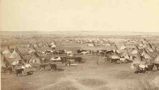
The second battle of Adobe Walls (near Amarillo) took place on June 27, 1874, when a buffalo hunters' camp, built in the spring of that year in what is now Hutchinson County, about a mile from the adobe ruins known as Adobe Walls. This camp consisting of several businesses, was attacked by a party of about 700 Plains Indians, mostly Cheyennes, Comanches, and Kiowas, under the leadership of Quanah Parker and Isa-tai.
Most of the hunters at the camp were awake repairing a broken ridgepole when the Indians charged at dawn. The defenders, twenty-eight men and one woman, gathered in (Jim) Hanrahan's Saloon, (Charlie) Myers and Leonard's Store, and (Charles) Rath and Wright's Store and repelled the initial charge with a loss of only two men.
Hunters in the vicinity were notified of the attack on Adobe Walls, and by the end of the fifth day there were more than 100 men at Adobe Walls. A rescue party arrived after the Indians had given up the fight and retired.
The significance of this fight is that it led to the Red River War of 1874-75, which resulted in the final relocation of the Southern Plains Indians to reservations in what is now Oklahoma.
RED RIVER WAR ENDED AT PALO DURO CANYON (Spetember 1874)
In response to the attack at Adobe Springs, Col. Ranald S. Mackenzie led the 4th United States Cavalry from the south in an attempt to trap the Indians where they were camped. This campaign beginning with the second battle of Adobe Springs and ending with the battle of Palo Duro Canyon was known as the Red River War. Mackenzie's troops pursued several small Comanche bands into Tule Canyon and defeated them. Mackenzie then reached the edge of Palo Duro Canyon on September 28, 1874, guided by the Tonkawa chief Johnson.
Mackenzie's soldiers and scouts destroyed Red Warbonnet's village causing many Indians to flee the canyon for the open plains. Some of the warriors fought back, sniping at the soldiers, but their resistance was insufficient, and by nightfall Mackenzie's soldiers and Tonkawa scouts had captured the Indians' villages and most of their possessions.
The Indian losses at Palo Duro Canyon amounted to three warriors dead. One white was killed. Mackenzie's troops also captured more than 1,400 Indian ponies. Of these, forty were given to Johnson and another 300 to the other scouts. The remaining ponies were shot by the soldiers.
Most of the Indians' supplies, including their entire winter food supply, was also destroyed. Though the loss of life on both sides was remarkably small, the battle of Palo Duro Canyon is significant because it represented the southern Plains Indians' last effort at military resistance against the encroaching whites.
Their tribal government of the Comanches today operates near Lawton, Oklahoma.
HISTORY OF HALL COUNTY
The territory that eventually became Turkey in Hall County was originally a
part of Bexar Territory from 1836-1876.
Hall County, located in the southeastern Panhandle east of the High Plains, is bordered on the west by Briscoe County, on the south by Motley and Cottle counties, on the east by Childress County, and on the north by Donley and Collingsworth counties.
Hall County was named for Warren D. C. Hall, Republic of Texas secretary of war. Memphis, the county seat, is on U.S. Highway 287 about ninety miles southeast of Amarillo.
Hall county comprises 885 square miles of rolling plains and broken terrain crossed by the Prairie Dog Town Fork of the Red River, the Little Red River, and numerous lesser tributaries. The red and black sandy loam soils support a variety of native grasses in the rougher areas, and cotton, wheat, and grain sorghum crops in the tillable areas.
The Prairie Dog Town Fork flows eastward across the central part of Hall county. The Little Red River joins it near the center of the county. The North Pease River briefly meanders into the southern part of the county, where the Wind River, Cottonwood Creek, T-Bar Canyon Creek, and Running Water Creek flow into it. Mulberry Creek begins in Donley County and joins the Prairie Dog Town Fork in the western part of Hall County. Mountain Creek, Rustlers Creek, and North Baylor Creek form in eastern Hall County and flow into the Prairie Dog Town Fork in Childress County.
The Apaches occupied the Panhandle-Plains area in prehistoric times; in historic times the modern Apaches were pushed out of the region around 1700 by the Comanches, who subsequently ruled the Panhandle-Plains, including Hall County, until they were defeated in the Red River War of 1873-74 and removed to Indian Territory in 1875-76.
In 1876 the Texas legislature formed Hall County from land formerly assigned to Bexar and Young Counties. With the Comanches removed from the scene, buffalo hunters moved across the plains, and between 1877 and 1882 the buffalo in Hall County were exterminated. The Rath Trail, which ran from Fort Griffin to Adobe Walls, Texas, and then to Dodge City, Kansas, extended through Hall County and was used by buffalo hunters until they left the area, after which it led ranchers and their cattle in.
A number of major ranching operations moved into the area during the late 1870s and the 1880s. In 1876 Charles Goodnight and John Adair established the huge JA Ranch, which was headquartered in Armstrong County and spilled over into several surrounding counties, including Hall. The western part of the county, north of the Red River, was considered to be a part of the main JA Ranch into the early twentieth century.
In 1878 Leigh R. Dyer established the Lazy F Ranch in eastern Briscoe and western Hall counties. Charles Goodnight had taken this range by 1879; by 1882 it operated as the Quitaque Ranch of the JA. The Diamond Tail Ranch of William R. Curtis also appeared in 1879, spread over northeast Hall County, and extended into Donley, Childress, and Collingsworth counties.
In 1880, Thomas S. Bugbee and L. G. Coleman established the Shoe Bar Ranch to the east of the JA holdings in western Hall County; their ranch, operated informally for over a decade, became the Shoe Bar officially in 1891. In 1885 Orville H. Nelson started a small (twenty-section) ranch called the Bar 96 and began raising only full-blood Herefords.
The Continental Land and Cattle Company brought its Mill Iron Ranch to Hall County in 1888. This huge operation covered all of southern Hall County (east of the Quitaque Ranch) as well as large parts of Childress, Motley, Collingsworth, and Cottle counties. By 1890, seventy-nine ranches and farms had been established in the county and the population had increased to 703. Almost no crops were grown in the county at this time; the agricultural census for that year reported only seventeen acres planted with corn, the county's most important crop.
The large and powerful ranches eventually disappeared, however, as they were parceled out to land-hungry settlers who wanted the land for farms and stock farms. Many of these new arrivals came because of an important new railroad connection. The Fort Worth and Denver City Railway reached Hall County in 1887, and by March 1888 met the Denver, Texas and Gulf, which had been building southward from Denver to Texline.
By the late 1880s, Hall County was changed from a ranching to a farming area by the coming of the railroad. The growing population led residents to debate county organization in 1889, and in April 1890 a petition of organization was circulated. In a hotly fought election on June 17, Salisbury, the county's oldest town and only railroad stop, fought with Lakeview, near the center of the county, and Memphis, a new town on the railroad, for the being the county seat. Memphis won the election and was named county seat on June 23; Salisbury vanished by 1893, and Lakeview remained a small trade center with little chance to grow.
Construction of the railroad and county organization made Hall County a more attractive place to settle. By 1900, the county had 219 ranches and farms, covering some 718,876 acres. The cattle industry continued to dominate the local economy while crop farming was only beginning to become established. More than 82,500 cattle were reported in the county that year, while 1,013 acres was planted in corn and 891 acres was devoted to cotton. The county's population had more than doubled (to 1,660) since 1890, and pressure on the large ranches to sell land was becoming more intense.
The Diamond Tail had begun to sell its land piecemeal in 1895; it was all sold by 1905. The Bar 96 sold its land slowly between 1900 and 1905, and other county ranchers began to see the economic benefits of selling land. The JA began selling Lazy F acreage in 1906, and the Shoe Bar sold out to Swift and Companyqv in 1907; the ranch was then quickly sold to settlers in 1908. Only the Mill Iron Ranch held out during this land rush.
By 1910 there were 1,028 farms and ranches in the county, and the structure of the local economy had been transformed. Corn crops accounted for approximately 11,000 acres of production that year, and cotton had spread to almost 52,000 acres of county land. Settlers planted more than 15,500 fruit trees (mostly peaches) by 1910, and poultry was also becoming an important part of the local economy; the agricultural census reported more than 124,500 chickens, turkeys, and other domestic fowl on local farms. The number of people living in Hall County almost quintupled between 1900 and 1910, rising to 8,279.
As cotton production expanded, cattle ranching declined; 28,227 cattle were counted in Hall County in 1910, and only 18,804 in 1920. Land suited to ranching continued as small ranches or stock farms. The Mill Iron, which retained 200 sections for ranching purposes into the 1940s, remained the only sizable ranch in the county. The population grew as the number of farms increased. The census found 11,137 people living in Hall County in 1920 and 16,986 in 1930.
HALL COUNTY SUFFERS DURING GREAT DEPRESSION
Hall County lost more than a third of it's farmers as a result of the Great Depression. Though the Civilian Conservation Corps worked on a soil-erosion project in the county during the depression, the population of the county dropped to 12,117 by 1940, as dust-blown farmers left the land and moved on. Further, the consolidation and mechanization of agriculture after World War II pushed many more farmers off the land. The population of Hall County dropped to 10,930 by 1950, and by 1990 the number of residents had fallen to 3,905. Farm size increased steadily in these decades, however, and by the 1980s the only reminders of the pre-1930s economy were the hundreds of decaying, vacant farmhouses that dotted the rural landscape.
The bulk of the population of Hall County is found in the towns and communities, the largest of which are Memphis (1990 population, 2,465), Turkey (507), Estelline, and Lakeview. Other communities include Brice, Lesley, Newlin, Plaska, and Parnell.
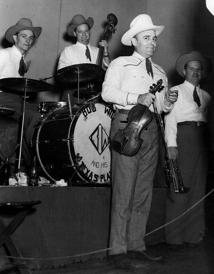
Special events in the county include Big Tom's Country Roundup, the Cotton Boll Enduro, and Bob Wills day, which is held in Turkey each April in honor of Bob (James Robert) Wills, the county's most famous native son.

Bob Wills, Born near Kosse, Texas and raised in Turkey, is probably the best known citizen of Hall County.
The Wills family settled throughout the county on farms near Memphis, Estelline, and Turkey.


BIBLIOGRAPHY: Inez Baker, Yesterday in Hall County (Memphis, Texas, 1940). Virginia Browder, Hall County Heritage Trails, 1890-1980 (2 vols., Canyon, Texas: Staked Plains, 1982, 1983). John Thomas Duncan, Economic and Social Movements of the Memphis, Texas Trade Area, 1908-1912 (M.A. thesis, Texas Technological College, 1942). John Thomas Duncan, "The Settlement of Hall County," West Texas Historical Association Year Book 18 (1942).
HISTORY OF TURKEY ROOST & TURKEY, HALL COUNTY, TEXAS.
Present-day Turkey is located at the intersection of State Highways 86 and 70, on the Burlington Northern railroad line in the southwestern corner of Hall County.

Business section of present day Turkey, Texas.
Prior to 1890, the territory that was to become Hall County was settled by native Americans and few white settlers lived in the region. In the early 1890s, a few anglo settlers moved into the area called Turkey Roost, for the huge populations of wild turkey that roosted in the trees along nearby Turkey Creek.

Wild turkey populations in the thousands once lined the turkey roosts near present day Turkey, Texas. In the 1870's, General Philip Sheridan reported a North Canadian River turkey roost just to the north of Turkey Roost that was more than three miles long.
However with the Oklahoma land run of 1889, a trickle of settlers coming thru the region turned into a flood, bringing with them an ever-increasing demand for timber, which they met by cutting many of the trees that lined the riverbanks. By 1925, wild turkeys in the Hall County region were so rare in the area that most people thought they were extinct.
TURKEY ROOST METHODIST EPISCOPAL CHURCH FOUNDED IN 1892
In 1892 a Methodist Episcopal congregation was organized at the home of W. M. Cooper.
TURKEY FOUNDED IN 1893
The town of Turkey Roost was shortened to Turkey in 1893, when a post office was established there in the dugout of Alfred P. Hall, the first postmaster.

Wagon train bringing settlers to Turkey, Texas. At first they were ranchers but soon became farmers as the railroads came through the area.
A Texas Historical Marker at Main Street between 8th & 9th Streets in Turkey carries the history of the First Methodist Church of Turkey, "
The Rev. J. D. Terry and seven charter members organized the Elizabeth Methodist Episcopal Church, South, on September 8, 1891, at the home of W. M. & Elizabeth Cooper. Worship services were held in homes and in the nearby Wolf Flat Community Schoolhouse until 1907. In that year a frame sanctuary and parsonage were completed. After a 1928 tornado destroyed the church building, the members built a basement structure and worshiped there until 1948, when an above-ground addition was completed. The church continues to serve the community. (1991)
Later John M. Gist became the postmaster and served until 1895, when the post office was discontinued.
In 1900 the Turkey post office was reopened, and by 1906 a school district had been established and a chapter of the Woodmen of the World had been organized.
A town plat was officially recorded in 1907.

The Turkey High School. Note: The former Turkey school buildings were purchased by The Bob Wills Foundation and city offices, the library, a senior citizens room, and the Bob Wills Museum are located in the former grade school building. The Foundation has built a Bob Wills monument and Bob Wills Park.
By 1914 about 250 people were living in Turkey, which included a bank, a hotel, a general store, and two groceries. A newspaper, the Turkey Gobbler, began publishing in 1919.
TURKEY INCORPORATED IN 1926
When Turkey incorporated in 1926, Jess Jenkin became the first mayor, and G. Katzkie and J. B. Miller were elected as aldermen.
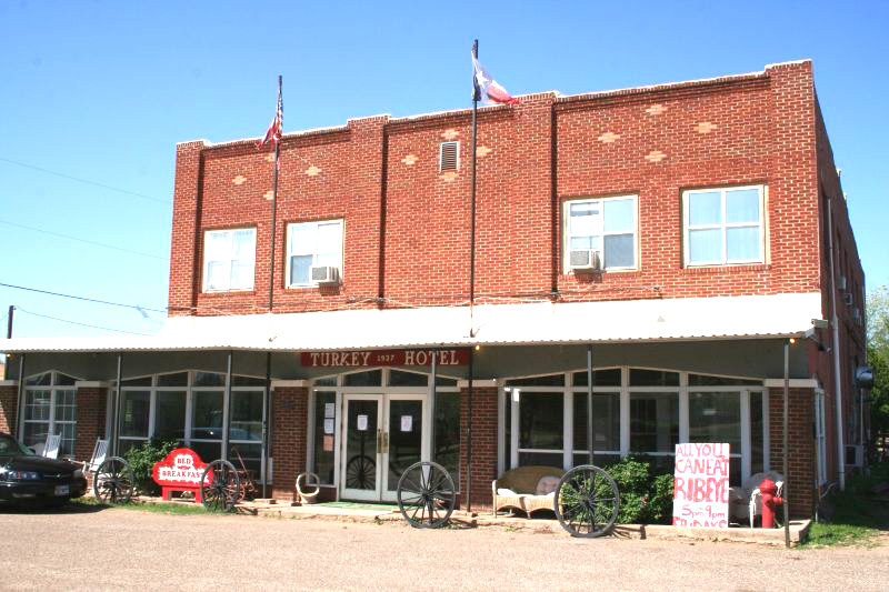
The Turkey hotel, listed on the National Register of Historic Property, opened in 1927 and currently serves as a Bed and Breakfast in the town's only overnight lodging. Located on the main drag at 3rd Street and Alexander.
In 1928, most of the business district of Turkey was destroyed by fire. However, the town soon had good news to celebrate as the Fort Worth and Denver Railway built through the town later that year making Turkey an important shipping point for area farmers and ranchers. By 1929, Turkey had two banks and about 1,000 residents. An Assembly of God church was built the next year. The Great Depression slowed growth during the 1930s. One bank closed in 1933, and the other in 1940; meanwhile, the population declined to about 975 by 1931 and to 930 by 1941. During the late 1940s or early 1950s the local economy revived, and by 1950 Turkey had some fifty businesses and 998 residents.
By 1955 about 1,005 people were living there, but the town began to decline again in the late 1950s. By 1958 only thirty-eight businesses were reported, and by 1961 the population of Turkey had dropped to 813. Only twenty businesses were operating in Turkey in 1972, when its population had fallen to 680. A 1981 map showed two schools and five churches in Turkey; in 1982 the town reported twenty-three businesses and 644 residents.
By 1990, however, Turkey had only twelve businesses and 507 residents. With the construction of the Bob Wills Museum and the Bob Wills Musical Celebration, new life was pumped into Turkey and the annual event seems to be gaining in popularity each year.

Turkey promotes it's most famous citizen, Bob Wills.
TURKEY ROOST MUSEUM
One of the area attractions is the Turkey Roost Museum located at 111 Main Street in Downtown Turkey Texas.

The Turkey Roost Museum project, begun in 1996 by Lawana Cruse, is located at 111 Main Street in Downtown Turkey Texas in the historic building once used as a hardware store, a grocery store and a home to many other businesses over the years. The Museum is open Saturdays from 9:30am to 11:30am & 1:30pm to 3:30pm.

Old Cotton Gin in Turkey, Texas

Bob Wills Monument in Turkey, Texas

Water tower marking Turkey, Texas

City limits sign marking the city of Turkey, Texas
This is a site under construction. We'll be adding old photos and stories of early-day settlers in the Muleshoe area.
If you have something you'd like to add to the site, send me an email.
Got any old Turkey or Hall County Photos or Stories you want to share? Send me an email!
 For questions or comments, send me an Email at: lenkubiak.geo@yahoo.com For questions or comments, send me an Email at: lenkubiak.geo@yahoo.com
|

Also see our history links on the Fort Tumbleweed Main Page. I spend a great deal of time researching Texas history and adding
topics of interest to our website for our internet viewers.
Bookmark us and come back
often (and tell your friends about us).
Thanks,
Len Kubiak
Fort Tumbleweed Main Page.
|
MORE PLACES TO GO
Don't forget to bookmark our site and come back often!! Thanks for visiting!!
COME BACK TO SEE US OFTEN!
|
Copyright 1996-2020. All rights
reserved by Leonard Kubiak. Fort Tumbleweed™ and forttumbleweed™ are trademarks of Leonard Kubiak. No Part of this Website nor any
of it's contents may be
reproduced in any manner without written permission.
|
Return to the Fort Tumbleweed Home Page
|