|
Lazbuddie Texas
History of the Lazbuddie Area and Parmer County

History of Lazbuddie

By Leonard Kubiak
PARMER COUNTY- THE EARLY DAYS
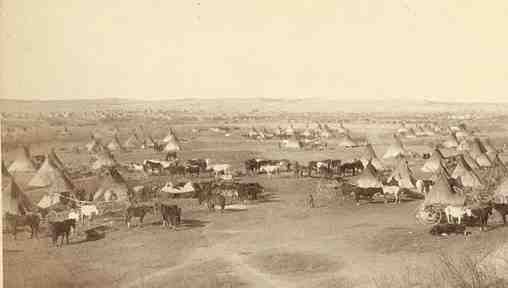
For thousands of years, the region that was to become known as Lazbuddie and Parmer County was home to a variety of Indian
tribes that made their villages along the area lakes.
Artifacts identified as belonging to the Paleo-Indian (12,000-6,000 B.C.) and Archaic (6,000-200 B.C.) cultures have been
found in the area, indicating it was occupied for more than 12,000 years.
When the first Europeans arrived in
the region in the 1500's, the area in and around Lazbuddie was home to a sizeable Apache Indian population. However, by the late 1700's, Comanches (Southern Shashones) and Kiowas
rode by horesback into into the area, hunting buffalo and raiding the Apache Indian villages sucessfully driving out the Apaches. Up until the early 1800's, large buffalo
herds grazed the open areas of what became Lazbuddie and Bailey County.

(1839/1841) PRESIDENT LAMAR DRIVES OUT MOST INDIAN TRIBES
President Mirabeau B. Lamar, who took office as President of the Republic of Texas at the end of 1838, had a very hostile attitude towards Indians than did Sam Houston. Lamar believed that the Indians had no integrity; thus, there was no possibility of peaceful negotiation or co-existence. The only solution to the violent clashes between whites and Indians was to rid Texas of the Indians--permanently.
Lamar sent a commission including David G. Burnet, Thomas J. Rusk, and Albert Sidney Johnston, to negotiate the removal of the tribe to the Arkansas territory. He also deployed about 900 army regulars, volunteers, and militia to East Texas.

President Lamar, Commander and Chief of the Texas Army Regulars responsible for Driving Most Indians out of Texas.
On July 15, 1839, several hundred warriors under Chief Bowl engaged the Texans near present-day Tyler. In the initial battle, the Indians were defeated, losing eighteen men to the Texans' three. The next day, the Texans pursued the retreating Indians and inflicted more than 100 casualties, Chief Bowl among them. They also burned the Indian villages and chased the Indians across the Red River into neighboring Indian Territory (Oklahoma).
In the aftermath of the Cherokee battles, many of the weaker or more peaceful tribes Texas were also forced to relocate.
By 1841, East Texas was almost entirely cleared of Indians. The Alabamas and Coushattas were exceptions. They were regarded as a peaceful tribe who had aided Texans during the Runaway Scrape (after the fall of the Alamo and Santa Anna's army was searching for Sam Houston's army). The Alabamas and Coushattas were granted two leagues of land along the Trinity River.
WESTERN INDIANS UNDEFEATED UNTIL THE 1870s
However, the western part of the Texas Republic was a different matter.
The Comanche, Kiowa, and Apache nations refused to be driven out of Texas and continued fighting the Texas army and Rangers until their defeat in the early 1870's.
SECOND BATTLE OF ADOBE WALLS(1874)
The second battle of Adobe Walls (near Amarillo) took place on June 27, 1874, when a buffalo hunters' camp, built in the spring of that year in what is now Hutchinson County, about a mile from the adobe ruins known as Adobe Walls was attacked by a party of about 700 Plains Indians, mostly Cheyennes, Comanches, and Kiowas, under the leadership of Quanah Parker and Isa-tai.
Most of the hunters at the camp were awake repairing a broken ridgepole when the Indians charged at dawn. The defenders, twenty-eight men and one woman, gathered in (Jim) Hanrahan's Saloon, (Charlie) Myers and Leonard's Store, and (Charles) Rath and Wright's Store and repelled the initial charge with a loss of only two men.
Hunters in the vicinity were notified of the attack on Adobe Walls, and by the end of the fifth day there were more than 100 men at Adobe Walls. A rescue party arrived after the Indians had given up the fight and retired. The significance of this fight is that it led to the Red River War of 1874-75, which resulted in the final relocation of the Southern Plains Indians to reservations in what is now Oklahoma.
RED RIVER WAR ENDED AT PALO DURO CANYON (Spetember 1874)
In response to the attack at Adobe Springs, Col. Ranald S. Mackenzie led the 4th United States Cavalry from the south in an attempt to trap the Indians where they were camped. This campaign beginning with the second battle of Adobe Springs and ending with the battle of Palo Duro Canyon was known as the Red River War. Mackenzie's troops pursued several small Comanche bands into Tule Canyon and defeated them. Mackenzie then reached the edge of Palo Duro Canyon on September 28, 1874, guided by the Tonkawa chief Johnson.
Mackenzie's soldiers and scouts destroyed Red Warbonnet's village causing many Indians to flee the canyon for the open plains. Some of the warriors fought back, sniping at the soldiers, but their resistance was insufficient, and by nightfall Mackenzie's soldiers and Tonkawa scouts had captured the Indians' villages and most of their possessions.
The Indian losses at Palo Duro Canyon amounted to three warriors dead. One white was killed. Mackenzie's troops also captured more than 1,400 Indian ponies. Of these, forty were given to Johnson and another 300 to the other scouts. The remaining ponies were shot by the soldiers.
Most of the Indians' supplies, including their entire winter food supply, was also destroyed. Though the loss of life on both sides was remarkably small, the battle of Palo Duro Canyon is significant because it represented the southern Plains Indians' last effort at military resistance against the encroaching whites.
Their tribal government of the Comanches today operates near Lawton, Oklahoma.
HISTORY OF PARMER COUNTY/LAZBUDDIE TERRITORY
The territory that eventually became Lazbuddie in Parmer County was originally a
part of Bexar Territory from 1836-1876 and located on the western border of the Panhandle of Texas, bordered on the west by New Mexico, on the north by Deaf Smith County, on the east by Castro County, and on the south by Bailey and Lamb counties. Farwell, the county seat, is on the Texas-New Mexico border, fifteen miles southwest of the center of the county and eighty-five miles southwest of Amarillo. Parmer County was named for Martin Parmer, an early settler and Texas Revolution veteran.
Parmer County Established in 1876
In 1876 Parmer County was established by the Texas legislature from lands formerly assigned to the Bexar District. However, little settlement occurred in the county until 1882 when the Capitol Syndicate agreed to build a new state capitol for Texas in Austin in return for 3,000,000 acres of land in West Texas.
TEXAS CAPITAL AT AUSTIN BURNS; XIT RANCH IS FORMED IN 1881
The Sixteenth Texas Legislature appropriated three million acres of land in west Texas to finance a new state Capitol building to replace the old capitol building destroyed by fire on November 9, 1881.
The Capitol Syndicate established the XIT Ranch to cover the $3.7 Million cost of erecting the state capitol, which was completed in April 1888. John Farwell, a member of the Capitol Syndicate, went to England and late in 1884 succeeded in forming the Capitol Freehold Land and Investment Company of London. By attracting wealthy British investors like the Earl of Aberdeen and Henry Seton-Karr, a member of Parliament, Farwell returned with the equivalent of roughly $5 million in American currency to finance the building of the state capital and to finance the conversion of 3 million plus acres into the mighty XIT ranch.
From the first, the Capitol Syndicate had intended to run cattle only until the land could be used for agriculture; long-range goals were to promote settlement, eventually subdivide the acreage, and gradually sell it off piecemeal.
Parmer County lay entirely within the lands granted to the Chicago syndicate for its huge XIT Ranch. For the rest of the century Parmer County remained unorganized and unpopulated, except for the XIT cowboys. The 1890 population of seven grew only to thirty-four by 1900, and ranching dominated the region.
According to the United States agricultural census for 1900, the XIT (the only ranch in the area at the time) extended across 150,000 acres of Parmer County land. The census reported 13,675 cattle in the county that year; only 350 acres were considered to be "improved," and no crops were reported. While the area was solely devoted to cattle in 1900, developments that would reshape the area had already begun to occur.
In 1898 the Pecos and Northern Texas Railway Company began construction of a ninety-five-mile branch line from Amarillo to the Texas-New Mexico border. On this line, which was eventually to run from Amarillo to the Santa Fe main line in Belen, New Mexico, grew several communities in Parmer County. Parmerton appeared in 1898 as a Capitol Syndicate townsite, while Black, Friona, and Bovina appeared the same year as switches and townsites on the line.
Farwell, established in 1904 and surveyed in 1905, was founded by the syndicate as a central point from which the company could administer the sales of XIT lands. The appearance of Farwell led to the quick demise of Parmerton.
In 1904 the Capitol Syndicate launched a campaign to sell the holdings of the XIT Ranch to land speculators, smaller ranchers, and farmers. Between 1904 and 1910 farmers slowly but steadily arrived to establish new operations, and by 1910 there were 161 farms and ranches in the county. Accordingly, a petition for organization passed through the county in May of 1907. On May 7 an election to choose county officials and a county seat was held. Parmerton became the county seat, but in another election held in December 1907, the county's voters chose Farwell to become county seat in 1908.
As the farm economy of the county expanded, the Pecos and Northern Texas Railway built a branch line from Farwell to Lubbock in 1913 to complement its earlier line to Amarillo. By the early 1920s a crude graded road, State Road 33 (now U.S. Highway 60), linked Farwell to Amarillo via Bovina, Friona, Hereford, and Canyon, while an even cruder track (later U.S. Highway 84) tied Farwell to Lubbock via Muleshoe and Littlefield. During the 1930s both of these routes were paved, and the primitive system grew to include dirt-surfaced farm and ranch roads. After World War II, a building and paving boom resulted in the road network of the 1980s.
By the 1980s Parmer County was recognized as one of the leading agricultural counties in Texas with an annual agricultural income averaging $215 million, a sum derived from a mix of cattle ranching, feedlot operations, and wheat, corn, cotton, and grain sorghum production.
BIBLIOGRAPHY: Frank H. Hayne, "Early Days in Parmer County," West Texas Historical Association Year Book 23 (1947). Highways of Texas, 1927 (Houston: Gulf Oil and Refining, 1927). Parmer County Historical Society, A History of Parmer County (Quanah, Texas: Nortex, 1974). S. G. Reed, A History of the Texas Railroads (Houston: St. Clair, 1941; rpt., New York: Arno, 1981).

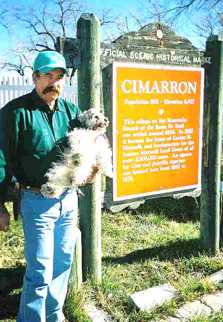
Texas Historical Marker describing the famous XIT ranch that included the Lazbuddie Territory.
A herd size of 150,000 was put together and by the turn of the century, 325 windmills and 100 dams had been erected on the XIT ranges. Cross fences divided the ranch into ninety-four pastures, and 1,500 miles of fencing had been completed. Cowhands were paid from twenty-five to thirty dollars a month. Because of droughts, blizzards, prairie fires, and declining markets, the XIT operated largely without profit throughout most of its lifespan.

One of 325 windmills that once pumped water for the XIT ranch.

Old XIT Brand used on millions of head of cattle during the lifespan of the famous XIT ranch.
By the late 1890s pressure from the British creditors were rising, and the Capitol Syndicate began the gradual process of selling out. The last parcel of XIT land was sold in 1963 by Hamlin Y. Overstreet, who had succeeded his late uncle as a company representative in Farwell.
The romance of the XIT Ranch, enhanced by the spread's sheer size, lives on in western lore. The voluminous XIT Ranch records are housed in the Panhandle-Plains Historical Museum in Canyon, and the old general office building still stands in Channing. In Dalhart memories of the ranch are kept alive in the XIT Museum and the famous "Empty Saddles" monument, as well as the annual XIT Reunion, complete with parade and rodeo. Other West Texas towns, including Muleshoe, Farwell, and Bovina, also advertise their common heritage with the XIT. The old Escarbada division headquarters, where Ira Aten and his family resided during his stint as foreman, is now part of the Ranching Heritage Center in Lubbock.
BIBLIOGRAPHY: Cordia Sloan Duke and Joe B. Frantz, 6,000 Miles of Fence: Life on the XIT Ranch of Texas (Austin: University of Texas Press, 1961). James D. Hamlin, The Flamboyant Judge: As Told to J. Evetts Haley and William Curry Holden (Canyon, Texas: Palo Duro, 1972). Laura V. Hamner, Short Grass and Longhorns (Norman: University of Oklahoma Press, 1943). Charles E. McConnell, XIT Buck (Tucson: University of Arizona Press, 1968). Ray Miller, Eyes of Texas Travel Guide: Panhandle/Plains Edition (Houston: Cordovan, 1982). Pauline D. and R. L. Robertson, Cowman's Country: Fifty Frontier Ranches in the Texas Panhandle, 1876-1887 (Amarillo: Paramount, 1981).
Lazbuddie Carved out of the Star Ranch
Lazbuddie in southeastern Parmer County, had its beginning in the early 1900's, when Thomas Kelly purchased the Capitol Syndicate's Red Tower Camp, comprising 55,136 acres that was formerly part of the XIT Ranch. Thomas Kelly developed the Star Ranch which was eventually subdivided and placed on the real estate market.
Lazbuddie Is founded (1924)
D. Luther (Laz) Green and Andrew (Buddie) Sherley purchased a tract from the Star Ranch in 1924 and opened a store, the Lazbuddie Commissary, at which a post office was established in May 1926. The Star Ranch school had existed in the area since 1906.
Founding of the Lazbuddie Community
A country town developed around the Lazbuddie Commissary and post office (Named after Laz and Buddie), and in 1927 the Star Ranch school got a new red brick building. By 1930 a second store and three churches had been established. Like most of the settlements in the Texas Panhandle,tent shows and medicine wagons were a common attraction in Lazbuddie bringing out the area ranchers and farmers who numbered about 75 at any given time until the late 1980's.
In the 1980s, Lazbuddie remained an active agricultural center with seven agribusinesses (including two gins and an elevator), four churches, and new school facilities. The post office was still housed in the original Lazbuddie store building.
The Lazbuddie Dam and Reservoir(1980)
The Lazbuddie dam and reservoir, built in 1979-80, on a small waterway known as the Running Water Draw six miles northeast of town, provides recreation and irrigation for area farmers and ranchers.
BIBLIOGRAPHY: Parmer County Historical Commission, Prairie Progress (Dallas: Taylor, 1981). Parmer County Historical Society, A History of Parmer County (Quanah, Texas: Nortex, 1974). Fred Tarpley, 1001 Texas Place Names (Austin: University of Texas Press, 1980).
This is a site under construction. We'll be adding old photos and stories of early-day settlers in the Lazbuddie area.
If you have something you'd like to add to the site, send me an email.
Also see our history links near the bottom of this webpage. I spend a great deal of time researching Texas history and adding
topics of interest to our website for our internet viewers.
The site is constantly growing. Bookmark us and come back
often (and tell your friends about us).
Thanks,
Len Kubiak
Got any old Lazbuddie Photos or Stories you want to share? Send me an email!
 For questions or comments, send me an Email For questions or comments, send me an Email

For questions or comments, send me an Email at
lenkubiak.geo@yahoo.com
|